A low-power wide-area network (LPWAN) is a wireless telecommunication wide area network designed to allow long-range communications at a low bit rate among things (connected objects), such as sensors operated on a battery. The low power, low bit rate and intended use distinguish this type of network from a wireless WAN that is designed to connect users or businesses, and carry more data, using more power.
The unique set of LPWAN characteristics in comparison with other wireless technologies in the best way possible suited for IoT (Internet of Things) and M2M (Machine to Machine) needs.
LoRa is LPWAN technology that enables power efficient wireless communication over very long distances. LoRa is a spread spectrum modulation technique derived from chirp spread spectrum (CSS) technology. LoRa Technology has amassed over 600 known uses cases for smart cities, smart homes and buildings, smart agriculture, smart metering, smart supply chain and logistics, and more. With 97 million devices connected to networks in 100 countries and growing, LoRa Technology seems to be a very important technology for implementation of IoT applications. Devices typically communicate directly to a sink node which removes the need of constructing and maintaining a complex multi-hop network. LoRa provides a range of communication options (center frequency, spreading factor, bandwidth, coding rates) from which a transmitter can choose.
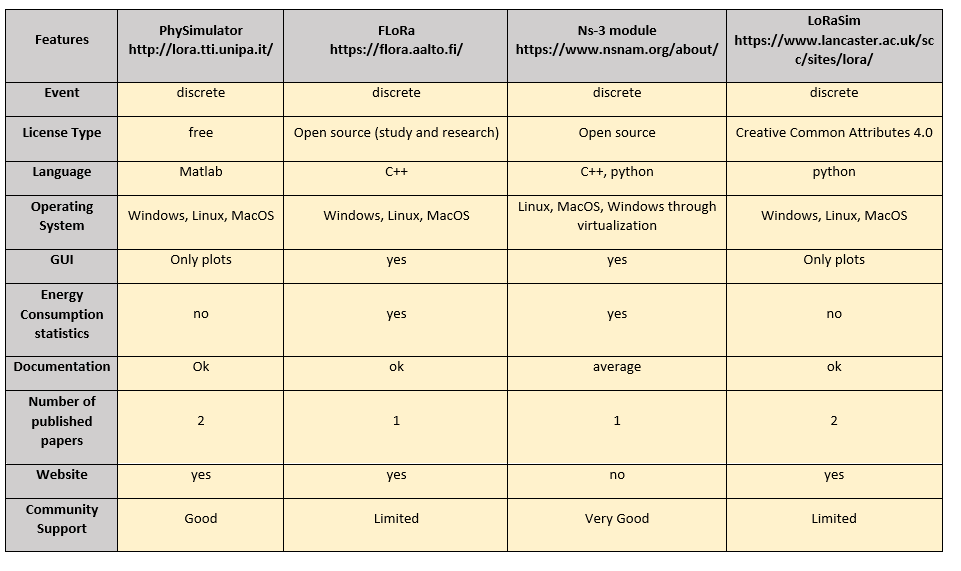
Simulation of LoRa networks is very important, because can be used for the initial design and evaluation of LoRa based applications without the need of costly implementations. Network design with specific parameters is a challenging task because the choice of the different parameters is not unique but should be suitable for the specific condition or application. For this reason, it is important to use a simulator.
Various LoRa network simulator are avalaible. The following table presents an overall comparison of the features of the most important LoRa network simulators.
One of the applications that LPWA technologies, and specifically LoRa can contribute and be used is the SAR (Search And Rescue) systems. SAR is the process were some people are in danger and need help. This process needs the cooperation of different domains and equipment depending on the case, e.g. in the sea, in mountainous terrain. Apart from, helicopters, boats etc, new ways have been introduced, such as UAV (Unmanned Aerial Vehicles). Thus, IoT solutions have started to be used more and more. One idea in this way is to use wearable technologies, to help on SAR operations.
See: The WeSAR project
IoT communication involves the selection of different parameters. One of the most crucial encounters is to have the appropriate resource allocation of the network. Thus, resource allocation can be focused on energy consumption, latency, throughput, packet loss and other network metrics. There are various techniques to accomplish this. One of the promising techniques is Machine Learning (ML). ML consists of different approaches and domains, such as supervised learning, and unsupervised learning, reinforcement learning. These kinds of techniques have started to be used in LoRa technology cases as well.
Narrowband Internet of Things (NB-IoT) is a Low Power Wide Area Network (LPWAN) radio technology standard developed by 3GPP to enable a wide range of cellular devices and services.
NB-IoT is a standards-based low power wide area technology developed to enable a wide range of new IoT devices and services. NB-IoT significantly improves the power consumption of user devices, system capacity and spectrum efficiency, especially in deep coverage. Battery life of more than 10 years can be supported for a wide range of use cases.
New physical layer signals and channels are designed to meet the demanding requirement of extended coverage – rural and deep indoors – and ultra-low device complexity. Initial cost of the NB-IoT modules is expected to be comparable to GSM/GPRS. The underlying technology is however much simpler than today’s GSM/GPRS and its cost is expected to decrease rapidly as demand increases.
Supported by all major mobile equipment, chipset and module manufacturers, NB-IoT can co-exist with 2G, 3G, and 4G mobile networks. It also benefits from all the security and privacy features of mobile networks, such as support for user identity confidentiality, entity authentication, confidentiality, data integrity, and mobile equipment identification.
NB-IoT is characterised by:
- excellent indoor coverage,
- support of a massive number of connections,
- cost efficiency,
- low device power consumption,
- optimised network architecture.
In the world of real time location systems, a number of loosely woven technologies have been introduced in order to track people and objects in real time. One major aspect of a location tracking system is the basic mathematical computation that determines the exact location. These days, navigation techniques remain relatively similar, replacing stars and landmarks with satellites and radio towers. Three major ways of determining a location exist, triangulation, trilateration and multilateration.
- Triangulation is the only one that measures angles rather than distance, and it is a preferred technique by the surveyors and researches. Building a system through triangulation starts by initiate two points (point 1 and point 2) with a known distance between them, which is established as the baseline. From these two points, the angle made by lines from distant points intersecting has to be measured with the base line using a device called Theodolite. These angles are then used to determine the unknown distances and thus locate the distant points.
- Trilateration is a more popular technique that is also used by the traditional GPS. Trilateration pinpoints a location by measuring distance. The general idea is that a satellite broadcast a signal for a GPS receiver to pick up. This is how the distance between a satellite and a GPS receiver is known. Similarly, when 3 such satellites come into contact with the GPS receiver, the exact location is determined.The intersection of the circles gives the location of the GPS receiver.
- Multilateration relies on the time difference in the arrival of signals to various base stations. This technique used for indoor and also outdoor positioning in confined regions. Time Difference of Arrival (TDoA) is a popular technique for localization as it does not require the transmitter to be synchronized with the receivers and requires only the differences between the timestamps of a transmission.